POINT CLOUDS
What Industries Use Point Cloud Data?
Point cloud data has become the new standard for the architecture, engineering and construction industry. Having a virtual model of the project gives companies the ability to effectively plan, design, construct, and manage projects. Point cloud data aids in analysis, design, construction sequencing, renovation, prefabrication, asset management, and facility modifications to name a few. Precise point clouds expedite design planning and reduce project costs and change orders.
Industries Utilizing Point Cloud Data
Agricultural Facilities
Architectural Documentation
Concrete Construction
Construction Clash Detection
Design Build
Energy & Utilities Engineering
Government, Defense & Military Sector
Healthcare & Pharmaceutical
Historical Documentation & Preservation
HVAC & MEP Coordination
Industrial, Manufacturing, Assembly & Distribution Facilities
Mixed Reality & 3D Projection Mapping
Office & Commercial Buildings
Overhead Clearances
Oil & Gas Facilities
Power Plants & Process Plants
Real Estate
Stadiums, Arenas & Theatres
Telecommunications
Schools & Universities
Subsurface Utility Engineering
Virtual Design and Construction
Water & Wastewater Treatment Plant
Accident Reconstruction
3D Video Gaming & Software Development
Core Capture Point Cloud Services
Point cloud data is transforming how architecture, engineering, and construction are documented, planned, and executed. By capturing precise existing conditions, Core Capture helps architects, engineers, contractors, and facility managers collaborate from the start — minimizing rework, enhancing coordination, and enabling faster, smarter decisions.
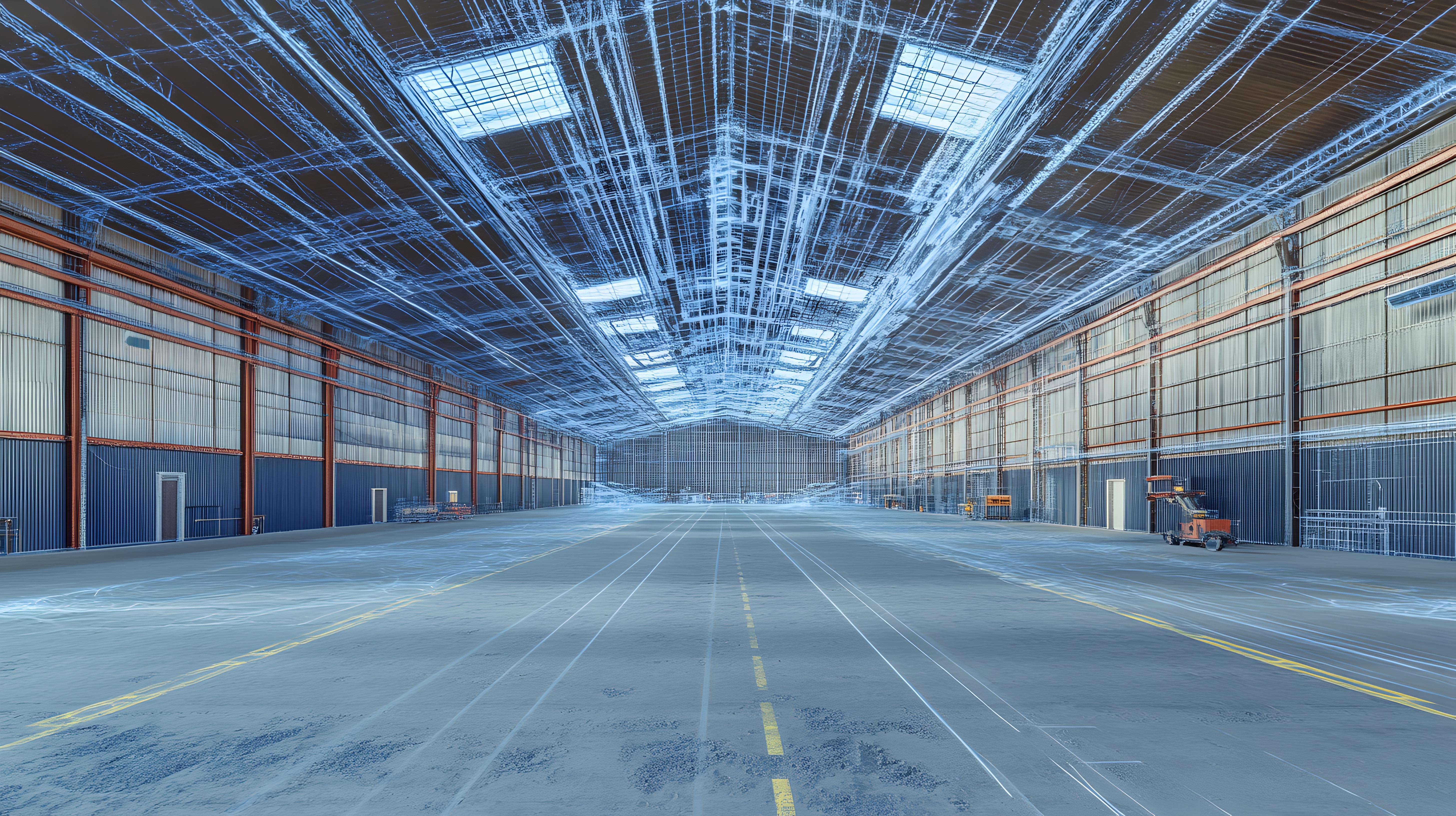
At Core Capture, we utilize survey-grade Leica laser scanners to collect millions of 3D measurements with exceptional accuracy, producing dense and dependable point clouds. These digital datasets form the foundation for as-built documentation, scan-to-BIM workflows, and existing conditions modeling.
Our expert team converts this data into 2D CAD drawings, 3D BIM models, and interactive visualizations, delivering structured, high-fidelity files with typical tolerances of 2–4 mm. Whether you’re designing, renovating, or managing a facility, Core Capture equips you with the spatial clarity to plan confidently and avoid costly surprises.
How Is a Point Cloud Created?
A point cloud is generated through 3D laser scanning, a process that captures millions of spatial measurements in seconds. At Core Capture, we use high-precision Leica scanners to emit laser pulses that bounce off surfaces and return to the scanner, recording each point’s position in space. These individual measurements combine to form a dense “cloud” of data points that accurately represent the geometry of walls, floors, ceilings, and structural elements. The result is a highly detailed digital snapshot of existing site conditions — ready for use in CAD, BIM, and other planning and design workflows.
Why Is a Point Cloud Important?
Point clouds are a powerful tool for capturing the reality of your space — quickly, accurately, and in high detail. They serve as a digital foundation for design, coordination, and decision-making by turning physical environments into rich, measurable datasets. Whether you’re renovating, expanding, or starting from scratch, a point cloud allows your team to visualize and analyze existing conditions with confidence. From there, our experts can transform that data into tailored deliverables like 2D drawings, 3D BIM models, and visual walkthroughs — all designed to reduce uncertainty, support collaboration, and move your project forward with fewer surprises.
Is a Point Cloud a Model?
Not exactly. A point cloud is not a finished model — it’s a highly accurate 3D representation of real-world conditions, made up of millions of measurement points captured by laser scanning. While it looks like a model, it’s actually raw spatial data that serves as a reference for creating detailed 2D drawings and 3D BIM models. Think of it as the foundation — the first step in turning your site into usable documentation for design, renovation, or construction. At Structra, we use point clouds to build intelligent, to-scale deliverables tailored to your project’s needs.
Is a Point Cloud a Survey?
While point clouds offer a high level of precision, they are not a replacement for a traditional site survey. Point clouds capture as-built conditions in remarkable detail and are ideal for visualizing existing structures and generating 2D or 3D documentation. However, they do not meet the same legal or quality standards as a certified survey. For example, if exact steel locations are needed for fabrication or construction, we recommend using point cloud data in conjunction with a professional site survey. That said, point clouds can still provide reliable spatial references — such as centerline dimensions of structural elements — to support planning and design efforts with confidence.
How Long Does It Take To Create a Point Cloud?
The timeline for creating a point cloud depends on the size and complexity of the site. We generally allocate one full day for most scans, though larger sites may require several days to complete. After scanning, the data must be registered before it can be delivered to the client—a process that typically takes 2–3 days. If additional deliverables such as 2D CAD drawings or 3D BIM models are needed, more time is required for accurate modeling by our experienced technicians. We’ll always work with you to establish a realistic schedule based on your project goals and deadlines.
Will The Point Cloud Be Colorized?
At Core Capture, we provide our clients with colorized point cloud deliverables that combine the precision of LiDAR-based 3D scanning with the visual context of high-resolution imagery (photogrammetry). This hybrid approach enhances spatial understanding by adding realistic color to detailed geometry. Environments with consistent, high-quality lighting yield the best results for colorized point clouds.
What Is Point Cloud Registration?
Point Cloud Registration is the critical process of aligning and merging individual laser scans into a unified, accurate point cloud. After data is captured onsite, our team “stitches” the scans together to create a seamless 3D representation of the space. Proper registration is essential for producing precise measurements and reliable deliverables such as 2D CAD drawings and 3D BIM models. At Core Capture, this step is handled by skilled professionals to ensure your final point cloud accurately reflects real-world conditions—typically within millimeter-level tolerance.
What Format Will My Point Cloud Deliverable Be?
There are several point cloud file formats available, each with specific strengths depending on the type of scanner used and the software workflow. Different laser scanners generate raw data in varying formats, and software platforms have unique capabilities for exporting and managing this data. At Structra, we commonly work with industry-standard formats like .E57 and .PTG, as well as Autodesk Recap files in .RCS and .RCP formats. We’ll help determine the right format for your needs, ensuring compatibility with your design or modeling environment.
What Deliverables Can You Create With The Point Cloud Data?
To produce advanced deliverables, point cloud data is imported into professional CAD or BIM platforms—such as Autodesk Revit, AutoCAD, or Navisworks—where it is modeled into precise 3D geometry. This transformation requires both technical skill and field awareness, as experienced technicians interpret the point cloud to create solids, surfaces, and other key elements. Structra provides tailored 2D and 3D deliverables at the level of detail that best fits your project, whether you’re looking for basic floor plans or highly detailed digital twins.
